One very cool thing I discovered: tribal license plates. I never knew of their existence. Instead of having Oklahoma tags on their cars, many sported Wyandotte Nation tags.
I wanted to avoid the interstate highway to get to East Texas because it would have been easy. We don't do easy on this trip. No, I had the choice of two somewhat parallel scenic road meandering South, one in Oklahoma, the other in Arkansas. I've had a hankering to see Arkansas, so I hopped a little East.
I had the scenic OK route mapped out by Mapquest and it wouldn't have taken me but 20 minutes to find my way back to it, but I struck out to AR with no more than a US atlas book woefully lacking in detail. Add to it that my reading glasses were stashed away in my luggage, so reading the small print on the map was impossible anyway.
Eventually, I found myself at Devil's Den State Park. A quick run should ease the pain in my leg, right? The park was full due to the long weekend, so I asked the ranger about a back country trail. My eyes lit up when he pulled out the special permit I would need to hike the trail. Rugged, isolated, no cell phone service, music to my ears. I was even instructed to call in when I was back at my car. Geez, how tough can this trail be? Toenail #3 a goner, that's how rocky it was.
The Butterfield Trail is a 15 mile loop. I planned to run in a couple miles and turn around and run back out. Simple. Nope, we don't do simple. Unlike the other Devil's Den trails that come with nice color brochure maps, the Butterfield map was pulled out of back filing cabinet. It looked like a mimeograph from the 50's. I was so blurry, you couldn't tell road from trail or waterway! I may just have it framed!
 |
| Cole kept leading me back to this spot and I finally figured out that we were to cross the river to connect to the trail on the other side. Markers would have been nice! |
In lieu of retracing my steps, I tried to jump onto a connector trail and make my own 4 mile loop run. We ended up running 9.5 hard miles. Oops. Ordinarily, I welcome the opportunity to get lost in the woods, but I did have folks waiting for me in Texas!
 |
| The current was strong and Cole was insisting that he be carried across. |
 |
| 9.5 miles through Devil's Den SP and Ozark National Forest |
What a gorgeous area. If I ever leave Alabama, you can forward my mail to the Ozarks in Northwestern Arkansas. Farmland interspersed with mountains, I love it. Sparsely populated too! If it weren't for my livestock, I may be harder to find: Northern Maine or Minnesota is where I may decide to set up a permanent camp.
Unfashionably late, I rolled into Lindale, Texas around 10 PM, having driven through the first and only storms of my entire trip. Once again, Gayla rolled out the red carpet for me and the Colemeister. I had hoped to take everyone out for supper to celebrate the last day of school. Instead, she had a feast waiting for me!
A late evening and part of the next morning is hardly enough time to catch up with one's best friend.
Next time, I'll plan my stops at friends' houses on the beginning leg of the journey, not the end when time is fleeting. In my defense, if I had done just that on this trip, I would have been in KS and TX during the tornadoes, in MN and Dakotas during their deluge of rain and my passage through WI may have been blocked by the big forest fire that I avoided by one day.
More motivation to move the Arkansas. I'd be closer to the Mitchell's, Gayla and my crazy twin in OK, Gina.
 |
| A good boy scout helping an old lady out to her car. |
The young man in the picture is The-Kid-Formerly-Known-As-My-Stepson, a.k.a. my nephew, a.k.a. my best friend's son. Albeit out of character for me, for simplicity's sake, I shall from now on refer to him by his name, Sebastian.
 |
| Gayla being pursued by Sebastian. Notice how smart Russ is to stay out of the melee! |
 |
| Sebastian has caught his next victim. |
 |
| A campground full of friendly people. One even brought her laying hen (the crate is barely visible in the lower left corner). Obviously not as lucky as me. I have my neighbors pet sitting my flock! |
 |
| Fun to find horses everywhere in the woods! |
 |
| Wide enough for wagons. |
 |
| Garmin conked out again. Total was 5.5 to 6 miles. |
Cole was struggling with the heat and humidity. He had me a little worried for a while. I used all my water to try to cool him down.
When we stopped in the historic town of Natchez, MS, I opted to walk rather than run.
 |
| Overlooking the river. |
 |
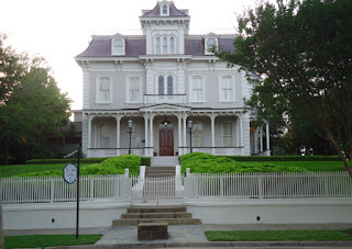
| Natchez house. |
 |
| I love the variety of architecture styles all in one area! Empire, French Revival, you name it. |
 |
| Trying to keep monsieur from diving in after the koi. |