Thursday, October 31, 2013

More Utah

The map of southern Utah is a crazy quilt of state and federal parks, BLM lands, national monuments and wildlife refuges. Too many to see in so short a time.

First order of business: find the road less travelled.


You never know what zany hole in the wall you'll find.  Check out this underground convenience store on Hwy 24 in Hanksville.

First park:  Capitol Reef National Park.


These rainbow colored sandstone reefs jut out of the canyon.


Here's a van for scale.


The canyon's first pioneers lived in this tiny, tiny house.  Ten children, ten.  Of course the house was too small, but they were resourceful.  The eldest boys slept in a cave, the eldest girls had a better situation, they got to sleep in the covered wagon.


How on Earth did they have the courage to persevere in this hostile environment?  How did they even get here without rappelling equipment?  And what topsoil?  Without dynamite, how are you supposed to plow?


A successful settlement developed around fruit orchards, the apple trees survive today. The schoolhouse was built in the rubble field below a 1000' cliff.
 

Next great road:


Teeth jarring ride, but I was on a mission.  I saw two hunters coming down from a mesa in the distance and I needed to know what they were hunting.  Curiosity killed the cat. 
One hour later...my interrogation was over, I'd eaten up their offered farm-made cheese curds, drank their water and gotten the best advice on what to see, where to hunt and where to fly fish. 
These two Utah guys were such characters! The one subconsciously groomed his long, white handlebar moustache like a cat, with a comb he flicked out of his pocket.  His buddy was the 69 year old better looking twin to Sam Elliott.  And, oh yeah, it was deer that they were tracking -- almost forgot. 

This was the first sight they suggested:


Can you see the ledge that is partially obstructed?  That's a 700 year old Puebloan granary.  To safeguard their corn and grains from moisture and rodents, they constructed block cellars and sealed them with mud...antique Tupperware.

Next suggestion:  take Route 12.  Scenic hardly describes how phenomenally gorgeous the area.


The beginning of the drive into Dixie National Forest.  Spectacular!
 
 
Certified tree hugger putting the moves on a Ponderosa pine.  The biodiversity in this forest is incredible.  In 80 miles, I traversed 7 different ecosystems, from desert floor to subalpine mountaintops.


I stopped here and there to hike around, collect rocks, photograph lichen and stuff pine cones in my pack for future identification.  As Cole and I eat more of our two week supply of food, more space is freed up for rocks.  Just for clarify...I don't pick from archeological sites. At Chaco, I spied two different types of rock I'd never seen before and found them off-site down by an abandoned ranch. 


Further down the road, in the canyon, is the ranching town of Boulder.  Up until the mid 1980's, Route 12 wasn't paved, leaving the town cut off from the outside for up to 6 months at a time. 
They still do things the old fashioned way.  I drove through a cattle roundup:  horses, herding dogs, snorting cattle.  I wanted to talk a picture but the cowboys seemed really annoyed to have me in the melee.  I satisfied myself by arriving at the chutes (made from logs) before the cattle.


Next treasure: Grand Staircase-Escalante National Monument. 


The road follows the narrow backbone of a high ridge.  One false move and you're tumbling down hundreds of feet.  No sissy guard rails here, they give you fair warning with a few signs and let natural selection take care of those texting while driving!


What shoulder of the road?
 
Last stop before dusk:  Kodachrome State Park, so named by a National Geographic expedition for its marvelous colors.
 
More dirt roads to navigate mean less visitors, pity for the parks' coffers, selfishly better for me.


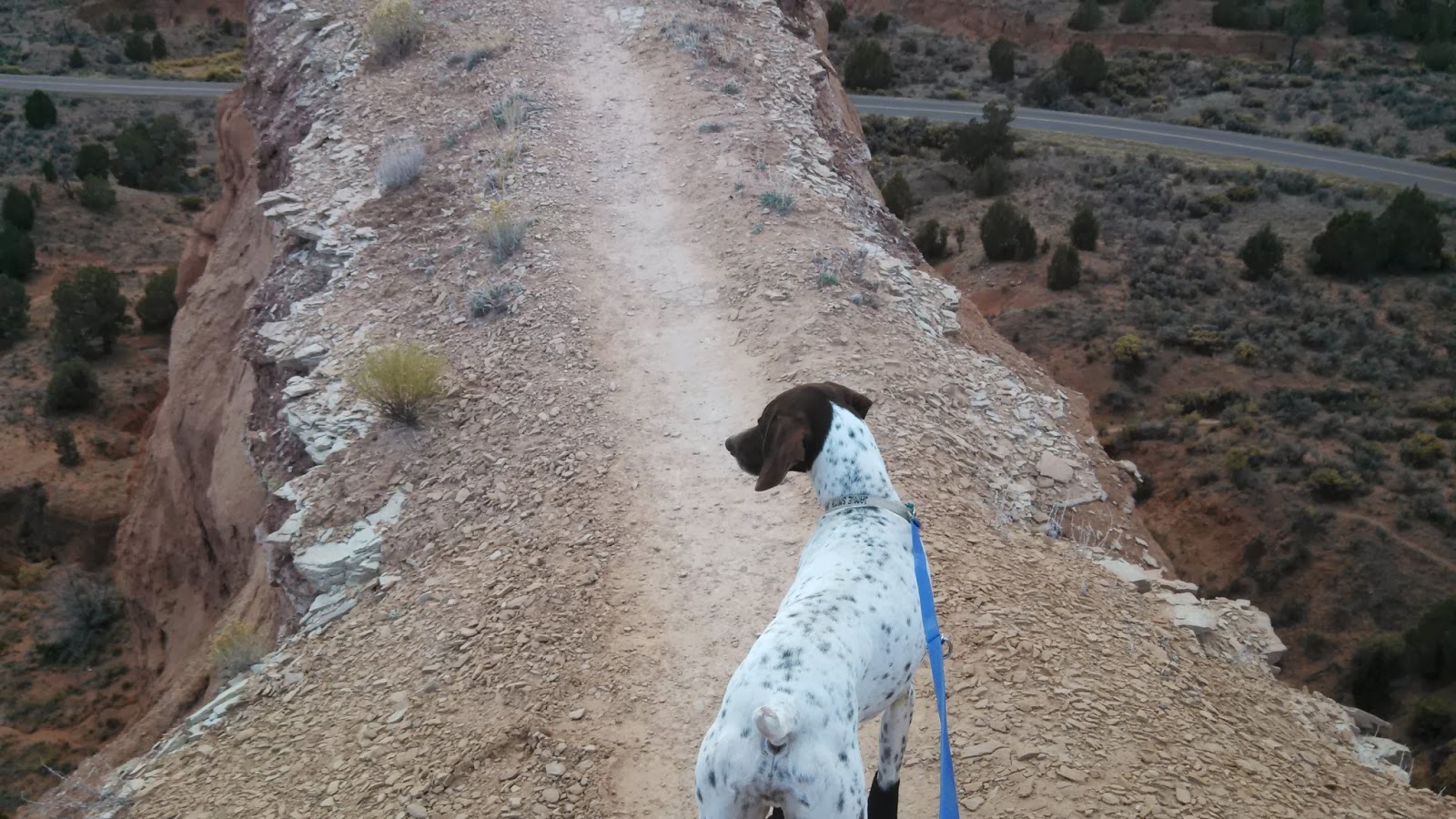
Not a trail for those suffering from vertigo, palpitations or clumsiness.


Not bad for one Sunday.

Wednesday, October 30, 2013

Goblin Valley Ultramarathon

Saturday morning before the sun arose, Cole and I were toed up to the starting line of our first ultra marathon.  A baby ultra, only 50k, or 32.something miles.  A fellow from Oregon had run it with his dog a few years ago and he recommended it to me.


It's called a trail marathon, but most of the 'trails' are dirt roads.  But, not all.  Recently, the Forest Service has paved a 6 mile section heading out of the park towards a popular camping area in Little Wild Horse Canyon.  The new pavement is the kind that is so textured it makes your tires rumble...not good for a dog's feet.  The race website hadn't updated that change. 


Spotting wildlife:  deer, pika (cutest cross between a mouse and a chipmunk) and lizards darting out in front of us.


At the turn around point after a long climb up the butte, mile 16 or so.  Cole tanked up on broth and my can of salmon.


Approximately every 4 miles had an aid station was manned by very tired Mormon teenagers.  They were hilarious!  The night before they'd had a dance, maybe 2 hours of sleep before being loaded onto a bus and driven 2 hrs into nowhere.  Some were up and chipper, others like these two girls quickly sat back down after chasing us with water cups and a few others were curled up in fetal positions in the sand and never woke up when we passed them.


"Who moved the finish line?"

The real fun didn't begin until we came back to the paved section.  We'd been trucking along nicely on the sand, but Cole refused to run on the pavement.  The shoulder of the road was too rocky and I tried to run off in the boonies parallel to the road.  Half the time it worked, but many times these thorny weeds blocked our path.

The race director passed me in his Jeep and I asked him to bring me my drop bag with Cole's boots from the halfway aid station.  Meanwhile, Cole and I walked along the road, waiting.  He finally came back with bad news, he didn't make it all the way to the halfway point, he was on his way to unload supplies at the finish line, he'd go back ASAP for the bag.  Well time was wasting, Cole wasn't having a good time any more, I'd missed my chance at sending him in the Jeep to the finish line, so I picked him up and carried him for about 2 miles.  I alternated from the over the shoulder carry (easier for me) and the in the front carry (more comfy for him).  For a while I had him piggy backing, that worked well until he flinched and I realized that if he fell backwards he might crack his head open.  Another runner who's hip had blown out offered to carry Cole for a while.  I couldn't accept, he was limping!

Thankfully, as we got closer to the finish line, the area off the road was runnable again.  I was the one slowing us down now because of my blistered feet.  At mile 26, I had take my socks off and used my hair ties to fit Cole with booties.  Sand and those dang thorns were filling my shoes.


We came in close to last at 6 hrs and 47 minutes, but we both got medals for finishing, so all's well that ends well! 


The last mile was through the Goblin Valley.  I wasn't interested in the scenery by that time, so we came back after a shower and a nap to properly visit.


The mushroom formations are called hoodoos, carved by wind and water after a receding inland sea...millions of years ago.


How cool is that?


Peek-a-boo.


Three entire valleys full of 'goblins' to explore. 


Cool facts:  the park's limited electricity all comes from solar power, the water is from a well and is heated with propane and, like most everywhere else I've been, none or limited cell phone service.

Utah, the Beautiful


Hovenweep National Monument, Utah.  Hovenweep is the Ute Indian word meaning 'abandoned valley'.  Around 1300 AD, the Ancestral Pueblo Indians left their villages to only be rediscovered by a pioneer in the 1800's. 


Unlike the cliff dwellings at Mesa Verde and the rounded kiva structures at Chaco, the ruins here are unique because they appear to be tower fortresses.

The towers are perched on the edge of shallow cliffs or balanced on heaps of rocks.  Archeological pollen studies show that by 1200 most of the trees in the area had been cut. The increased population in these settlements was taking its toll on the environment.  The farming of corn, amaranth, beans and squash required irrigation, further depleting the valley.  It's believed that the shift from simple dwellings to semi-fortresses was for the protection of water.  Most tower houses were built atop a natural water seep or spring.  Water rights-- age old problem.  Alabama, Georgia and Florida have been embroiled in a decade long legal battle for water rights, do you think they could learn from the past?  Nah, it's human nature, we squander the bounty and fight over crumbs until nothing is left.  When Cajon Canyon was completely depleted, the Puebloans had to abandon their valley.

 
With dusk upon us after our run around the Rim Trail, I wisely decided to avoid playing bumper cars in the dark with the livestock on the road and I camped out at Hovenweep.


I could hear the zipper of another camper's tent 500 feet away and it sounded 5 feet away.  The other fellow campers (maybe 8 of us in all) were so respectful of the quietude of the area, no dogs barking, no one slamming car doors, no generators, no music.  The lack of light pollution makes the stars appear to be so close that you could reach up and pluck one out of the sky.  In Alabama, I can work outside by moonlight when the moon is full, otherwise a head lantern is necessary.  Here, the half moon projected more light, it was crazy to be walking around at midnight casting long shadows.


As soon as the sun was up, Cole lead an expedition into the canyon.  We hiked 10 miles before lunchtime. 


It was my turn to get stuck in a crevice on the trail, yes, this is the only way down to the canyon on the trail!  Cole mocked me.


Rock cairns such as the one Cole found are the only trail markers.  Many cattle paths are more worn than the hiking trails, making it easy to wander off in the wrong direction.  My dogs has learned after a few thousand miles of trail running (no exaggeration on the mileage) how to stay on trail.  He uses a combination of sight and smell.  I'm sure he follows the scent of previous hikers.  This trail confused him at first.  He kept his smeller to the ground and would turn back to give me the "I dunno" look.  After a mile or so of correcting him, he started to recognize the cairns as markers.  Who says you can't teach an old dog a new trick?  When unsure of the direction to take us in, I'd watch him scan ahead for a pile of rocks and make a bee line for them.  He is my wonder dog!


We made it to the Holly Settlement just as the ranger came in from the other direction to patrol the area.  So, I got a personal tour of the ruins. Apparently, no one bothers to hike up to this site, explaining why Cole couldn't get a scent.  She showed me the petroglyphs that were a part of their way to calculate growing seasons.  Would you know what day it was if you lived in a vacuum?  The Puebloans marked spots where to Sun would hit only during an equinox, that served as their calendar.  Otherwise, a warm week might have fooled them into planting their precious seeds in February instead of the more appropriate March.


The far tower was built directly atop a big boulder.  Access was possible only with a ladder.


Peering down into the canyon.  My fearless leader had to wear his boots for the entire hike.  The ground is too rocky.  We had to wrap up our excursion before it got too hot because the boots prevent heat from dissipating from his pads.


Heading North.


Church rock on the road to Moab.


Wilson Arch.
 
I stopped in Moab for coffee, oh yeah, I fell off the wagon.  Coffee is my friend once again!  Moab is home central for mountain bike junkies and your garden variety of eccentric people.  The coffee shop owner had grey dreadlocks, tattoos that needed ironing and enough piercings to fill a tackle box.  Apart from all that she didn't look too bad for her 66 years.  Her cranberry eyes made me suspicious that the smell burning my nostrils wasn't incense burning.  Her brownies and cookies looked scrumptious, but I thought it safer to pass.
 
True to form, I pulled into to Goblin Valley State Park after dark.


The view on Saturday.